
If you are hiking on the Peak Way Walk and you encounter path closures and diversions, we should be grateful if you would let us know so that we can advise other hikers via this page.
If you are planning to hike on the Peak Way Walk, you may find this link helpful Path closure register - Derbyshire County Council
STAGE 4
CUTTHROAT BRIDGE TO BAMFORD EDGE - ROUTE DESCRIPTION
We have received an enquiry to say that the route from Cutthroat Bridge to Bamford Edge (on Stage 4) is not easy to navigate. Therefore, these notes are to help hikers to make navigation easier in this area.
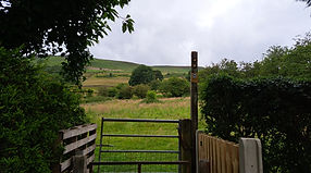
Once over the stile at the main road by Cutthroat Bridge, follow the track up passing the conifer trees.
When you are past these, look ahead for the dead tree on the right (estimated grid ref. 214865). Just before you reach this, look very carefully for the footpath down through ferns (it is easy to miss this) until you reach a small stream which you cross and follow the path through ferns up to the right.
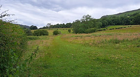
If you look at your OS map (or a navigation app on your smartphone), you are aiming to follow the path which passes the disused quarry - but this too is not very obvious being largely covered by ferns (grid ref. 212865).
Your next landmark to aim for is shown on the OS map as “Pillars”, a rocky outcrop (grid ref. 208861). It is difficult to give an accurate description on this terrain because there are several paths in various directions, but as a general rule you are aiming towards the right rather than left onto the rough moorland.
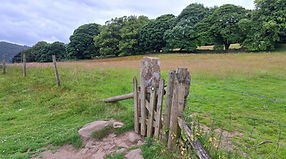
When you see the remains of a stone wall, aim for the corner of this and pass across it here on the path in front of you. You will soon join a broader path which will take you up to Bamford Edge, and from here, the route should be straightforward.

STAGES 4 and 5
BAMFORD CLOUGH BYWAY
There has been changes to the byway which links New Road to Bamford village known as Bamford Clough, and these changes affect the Peak Way route.
Derbyshire County Council has now completed works on the byway and it now has a tarmac surface (formerly a rough track). However, it has now been deemed unsafe, and metal barriers block part of each entrance (top & bottom) with a sign "Road Closed". We have visited the location and we have contacted Derbyshire County Council to ask for clarification. A Council spokesperson responded to say that the Temporary Traffic Regulation Order remains in place, and that the byway remains closed since outstanding engineering work is required to satisfy a safety audit. Any access made by the public is at their own risk.
At the time of our visit, we did see several walkers using it. However, because of the Council's response to our enquiry, we cannot advise walkers to use Bamford Clough until it is officially reopened by the Council.
In the meantime, we have found an alternative route which you may wish to use. The byway is extremely steep, and so you might want to consider this alternative anyway, regardless of the official position - it is slightly longer in distance, but the descent and ascent is much gentler.
This alternative route for Stage 5 (for Stage 4 the reverse applies) is as follows:-
From the Anglers Rest pub/cafe/Post Office continue uphill, passing West Lees Road. Shortly after, turn right up the road at the sign for Greenhead Park and walk between houses to the top where you pass through two metal gates in to a field. The path is diagonally left uphill and is clear to follow. Follow the path through fields until you reach the stile in the stone wall which meets New Road. Turn right uphill, and follow the road round the bend at the top to reach the stile by the gate mentioned on page 57 of the guide book.


STAGE 9
Derbyshire County Council has closed the footpath from Dovedale stepping stones for repairs from erosion of the path. It is scheduled to be completed by 22 June 2026, but the notice says that work may be completed earlier than advertised. The Council has provided instructions for a diversion as shown in the images which involves walking around Thorpe Cloud.


STAGE 12
TOWARDS NEW MILLS FROM TAXAL
Please note that, on leaving Taxal and walking towards New Mills, a new housing estate is being constructed at the time of writing (14/11/24). The information in the guide book is still accurate, but it may be slightly more difficult to locate the route between the houses. Follow the route across the grassed area and aim for the stile beside the metal gate and follow the path from here to the road.
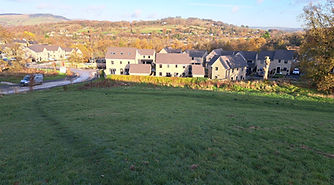
New housing estate

Follow the path by the stile and gate